|
#1
 May 8th, 2014, 05:53 PM
| ||||
| ||||
|
Will you please give me the University Grants Commission NET Geography (Paper III) question papers? As you want to get the University Grants Commission NET Geography (Paper III) question papers so here is the information of the same for you: Some content of the file has been given here: GEOGRAPHY PAPER – III Note : This paper contains seventy five (75) objective type questions of two (2) marks each. All questions are compulsory. 1. Most of the details of our present topography belong to the (A) Pre-Cambrian era (B) Paleozoic era (C) Mesozoic era (D) Cenozoic era 2. If you are sitting on the beach facing the sea on a sunny afternoon, the local wind will be (A) striking your back and continuing to the sea because of sea breeze effect. (B) towards your from the sea because of the sea breeze effect. (C) towards your from the sea because of the lapse rate effect. (D) striking your back and continuing to the sea because of the land breeze effect. 3. The temperature at which water vapours condense, is the (A) Relative humidity (B) Condensation point (C) Dew point (D) Evaporation point 4. Examine the following statements and select the correct answer using the codes given below : 1. The atmospheric air is never completely dry. 2. Water vapour can occupy as much as 4 percent of the atmospheric volume. 3. Water vapour in the atmosphere is always invisible. Codes : (A) 1 and 2 are correct (B) 2 and 3 are correct (C) 1 and 3 are correct (D) 1, 2 and 3 are correct 5. Chemical weathering is more effective than mechanical weathering in (A) Semi arid region (B) Arid region (C) Coastal region (D) Cool temperate region 6. A drainage system which is not related to the structure of the region where it occurs is called a (A) Radial drainage pattern (B) Trellis drainage pattern (C) Superimposed drainage pattern (D) Dendritic drainage pattern 7. Who calculated the slope based on the following formula ten = number of contours per mile contour interval 3361 (A) Wentworth (B) Raiz (C) Henry (D) Davis 8. Given below are the two statements one labelled as Assertion (A) and other Labelled as Reason (R) : Assertion (A) : The work of wind as an agent of gradation is not as widespread as that of water. Reason (R) : It is effective only in the desert regions of the world where rainfall is scanty and soil particles are loose. In the context of the above two statements which one of the following is correct : (A) Both (A) and (R) are true and (R) is the correct explanation of (A). (B) Both (A) and (R) are true but (R) is not the correct explanation of (A). (C) (A) is true but (R) is false. (D) (A) is false but (R) is true. 9. “The Two-Cycle Theory” of the origin of limestone caverns was proposed by (A) Davis (B) Swinerton (C) Gardner (D) Malott 10. All those processes which tend to bring the surface of the lithosphere to a common level are collectively known as (A) Gradation (B) Degradation (C) Aggradation (D) Mass wasting 11. Which one of the following atmospheric layers reflects radio waves that are transmitted from the earth again back to the earth ? (A) Mesosphere (B) Ionosphere (C) Troposphere (D) Stratosphere 12. According to ‘Single cell circulation’ model proposed by Hadley, the most important factor causing global atmospheric circulation is (A) subsidence at the equator (B) temperature contrast between equator and pole (C) the jet stream (D) rotation of the earth 13. Which of the following would likely to have the lowest albedo ? (A) Mirror (B) Fresh snow in the Arctic (C) Moist ploughed soil (D) Thick cloud 14. Given below are the two statements one labelled as Assertion (A) and the other labelled as Reason (R) : Assertion (A) : Hurricane cannot develop in the vicinity of equator. Reason (R) : Coriolis force is maximum over the equator. In the context of the above two statements which one of the following is correct : (A) Both (A) and (R) are true but (R) is not correct explanation. (B) Both (A) and (R) are true and (R) is the correct explanation. (C) (A) is true but (R) is false. (D) (A) is false but (R) is true. 15. When sun is shining vertically over tropic of Capricorn ? (A) Days and nights are equal over the entire globe. (B) Nights are longer than days in the Southern hemisphere. (C) Nights are equal to 24 hours over the Arctic region. (D) Days and nights are of 12 hour duration over Antarctica. 16. Which of the following statements is not true ? (A) Evaporation is directly proportional to temperature (B) Evaporation is more over land than ocean (C) Evaporation is higher over warm surface than on cold surface. (D) Evaporation reduces the amount of heat available in the atmosphere thereby reducing the temperature. 17. Match List – I with List – II and select the correct answer by using codes given below : List – I List – II a. Sublimation i. the energy absorbed is used to give the motion needed the escape the surface. b. Freezing ii. energy is released c. Evaporation iii. releases 80 cal/ gm d. Condensation iv. absorb 680 cal/ gm to change the state Codes : a b c d (A) ii iii iv i (B) i iii ii iv (C) iv iii i ii (D) iii ii iv i 18. Pelagic deposits consist of matter derived from algae and are mostly in the form of liquid mud known as (A) Blue mud (B) Ooze (C) Red mud (D) Coral mud 19. The average temperature of the surface water of the oceans is (A) 22 C (B) 15 C (C) 26.7 C (D) 18.6 C 20. Ecosystem has two components which are (A) Animals and plants (B) Trees and weeds (C) Frogs and men (D) Abiotic and biotic 21. All the ecosystems taken together in a geographical area form a bigger unit called (A) Community (B) Territory (C) Biome (D) Biosphere 22. Which one of the following ocean currents belongs to Indian Ocean ? (A) Canary Current (B) Antilles Current (C) Labrador Current (D) Agulhas Current 23. The Western Coast of Australia records higher salinity due to (A) Ocean currents (B) Wind direction (C) Dry weather condition (D) All the above 24. The highest salinity is found in the (A) Baltic Sea (B) Okhotsk Sea (C) Mediterranean Sea (D) Red Sea 25. Which of the following statements about synecology is correct ? (A) It is a study of individual species in relation to its environment. (B) It is a study of complex interrelationship of biotic communities. (C) It is essentially habitat ecology. (D) It is mainly social ecology. 26. Organic deposits made by living or dead organisms that form rock elevation like a ridge are known as (A) Corals (B) Conyons (C) Reefs (D) Guyots 27. Which one of the schools of thought first developed possibilism ? (A) German School of Geography (B) Russian School of Geography (C) French School of Geography (D) British School of Geography 28. Which one of the following is not a supporter of the theory of determinism ? (A) Wolfgang Hartake (B) R. Hartshorne (C) O.H.K. Spate (D) All the above 29. Who among the following noted first the regularity between the sizes of cities and their rank ? (A) Zipf (B) Jefferson (C) Auerbach (D) Christaller 30. Who among the following is an advocate of idealism in geography ? (A) Guelke (B) Gilbert (C) Samuels (D) Pocock 31. The statement that ‘a method by which one can rethink the thought of those whose actions one seeks to explain’ refers in human geography to the philosophy of (A) Phenomenology (B) Idealism (C) Existentialism (D) Positivism 32. Which among the following was responsible for the radical transformation of spirit and purpose of geography ? (A) Post Modernism (B) Humanism (C) Structuralism (D) Quantification 33. Which among the following was one of the forces responsible for continental drift according to Wegner ? (A) Tidal Force (B) Convection Currents (C) Tensional Force (D) Compressional force 34. Which one of the following States / Union Territories recorded the highest density of population as per census 2011 ? (A) Chandigarh (B) West Bengal (C) Kerala (D) Maharashtra 35. If economic landscape of a region is dependent on ‘transport principle’ of central place system, with the population size of 4.0 lakh of its highest order town, which one of the following population size of next lower order town is correct ? (A) 3.0 lakh (B) 2.0 lakh (C) 1.0 lakh (D) 0.5 lakh 36. Who defined settlement geography first time incorporating the concept of settlement pattern, house types and field system ? (A) Meitzen (B) Stone (C) Huntington (D) Trewartha 37. The sparsely populated countries have slow growth of industries because (A) of shortage of skilled labour (B) small population does not provide a good market (C) of both (A) and (B) (D) agriculture is more developed than industries 38. Which one of the following countries has the highest density of population ? (A) Bangladesh (B) Pakistan (C) Sri Lanka (D) India 39. The size of population in lower age group is large in countries where (A) Birth rate is high (B) Birth rate is low (C) Death rate is high (D) Death rate is low 40. The base of the age-sex pyramid is broad and apex is narrow in (A) Developed countries (B) Developing countries (C) Under developed countries (D) None of the above 41. Which one of the following market locations is optimal in given diagram of industrial landscape (A) c (B) b (C) d (D) a 42. Which one of the following matches in case of shifting cultivation is not correct ? (A) Ladang – Indonesia (B) Ray – Vietnam (C) Milpa – Mexico (D) Tamrai – Brazil 43. The polar regions are sparsely populated because (A) The growing season is short owing to low temperature (B) There are no mineral resources (C) The regions are forested (D) Both (B) and (C) 44. Which one of the following countries is the major producer of mica ? (A) India (B) U.S.A. (C) Brazil (D) China 45. Match List – I with List – II and select the correct answer using the codes given below : List – I (Sectors) List – II (Economic Activities) a. Primary sector i. Business organisation b. Secondary sector ii. Cultivation c. Tertiary sector iii. Handloom textiles d. Quarternary iv. transport services Codes : a b c d (A) i ii iii iv (B) ii iii iv i (C) ii iii i iv (D) iv iii ii i 46. Match List – I with List – II and select the correct answer from the codes given below : List – I (Industrial activities) List – II (Explanations) a. Processing activities i. Inputs are processed goods b. Fabricating activities ii. Major inputs are raw material c. Integrative activities iii. Involve neither inputs nor outputs d. Administrative activities iv. Inputs are processed goods undergoing little change Codes : a b c d (A) i ii iii iv (B) ii i iv iii (C) i iv iii ii (D) iii ii iv i 47. The number of persons expressed in terms of unit area of agricultural land is known as (A) Economic Density (B) Physiological Density (C) Arithmetical Density (D) Agricultural Density 48. Who among the following proposed a grand scheme of natural regions on a global scale by combining physical determinants of plants and animals life ? (A) Unstead (B) Herbertson (C) Whittlesey (D) Dickinson 49. Which of the following was not mentioned by Brunhes as essential fact of human geography ? (A) Facts of unproductive occupation of soil. (B) Facts of plants and animal conquest (C) Facts of destructive exploitation (D) Facts of manufacturing 50. Which one of the following factors is not affecting the voting behaviour ? (A) Religious (B) Castes (C) High level of literacy (D) Size of landholdings 51. Which indicator from among the following could be the best indicator of social-well being ? (A) Population growth rate (B) Literacy rate (C) Life-expectancy (D) Per capita income 52. Who among the followings gave the concept of ‘Rimland’ theory ? (A) A Ratzel (B) O.H.K. Spate (C) Spykman (D) Griffith Taylor 53. Who propounded the theory of ‘Heartland’ in political geography ? (A) Mackinder (B) Spykman (C) Smith (D) Raiz 54. A functional region is delineated on the basis of (A) Administrative boundaries (B) Field of interactions (C) Isolines (D) Physical divisions 55. Who in census of India applied the ‘ternary diagram’ for the functional classification of towns in India ? (A) P. Padmanabha (B) A.R. Nanda (C) Ashok Mitra (D) Chandrasekhar 56. Match List – I with List – II and select the correct answer from the codes given below : List – I (Author) List – II (Name of the Book) a. W. Christaller i. Rural settlement and land use b. V.L.S. Prakasa Rao ii. Metropolitan Hyderabad and its region c. Manzoor Alam & W. Khan iii. Regional Planning d. M. Chisholm iv. Central places in Southern Germany Codes : a b c d (A) i iii iv ii (B) ii i iii iv (C) iv iii ii i (D) i ii iii iv 57. Who authored the book entitled ‘growth Pole and Growth Centres for Regional Economic Development in India’ ? (A) Sen and Wanmali (B) Sadasyuk and Sengupta (C) Misra, Rao and Sundaram (D) Rao and Sundaram 58. Which one of the following states recorded the highest decadal growth rate of population between 2001 & 2011 as per census record ? (A) Bihar (B) Uttar Pradesh (C) Rajasthan (D) Arunanchal Pradesh 59. Match List – I with List – II and select the correct answer from the codes given below : List – I (Type of climate) List – II (Region) a. Aw i. Rain shadow zone of Karnataka b. Amw ii. Thar Desert c. BShw iii. W. Bengal & Bihar d. BWhw iv. Malabar Coast Codes : a b c d (A) iii iv i ii (B) iii i iv ii (C) ii i iv iii (D) ii iv i iii 60. Which one of the following rivers does not make a delta ? (A) Mahanadi (B) Godavari (C) Tapti (D) Ganga 61. Which one of the following rivers does not flow through Himachal Pradesh ? (A) Jhelum (B) Beas (C) Chenab (D) Ravi 62. Match List – I with List – II and select the correct answer from the codes given below : List – I (Rivers) List – II (Their tributaries) a. Krishna i. Chambal b. Brahamaputra ii. Indravati c. Godavari iii. Tista d. Yamuna iv. Bhima Codes : a b c d (A) iv iii ii i (B) iii iv ii i (C) iv iii i ii (D) i iv iii ii 63. Match List – I with List – II and select the correct answer from the codes given below : List – I (Soil) List – II (State) a. Alluvial i. Rajasthan b. Black soil (Regur) ii. Uttar Pradesh c. Desert iii. Maharashtra d. Red iv. Meghalaya Codes : a b c d (A) i ii iii iv (B) ii iii iv i (C) ii iii i iv (D) iv ii iii i 64. Which one records the lowest normal temperature in the month of January ? (A) Bikaner (B) Banglore (C) Jaisalmer (D) Firozpur 65. Match List – I with List – II and select the correct answer from the codes given below : List – I (Pass) List – II (State) a. Shipki La i. Arunachal Pradesh b. Niti pass ii. Himachal Pradesh c. Nathula iii. Uttrakhand d. Bomdi La iv. Sikkim Codes : a b c d (A) ii iii iv i (B) ii iii i iv (C) iv ii i iii (D) iv ii iii i 66. Which one of the following states has the lowest percentage of scheduled tribes ? (A) Arunachal Pradesh (B) Manipur (C) Mizoram (D) Nagaland 67. Which of the following hills forms the North Eastern edge of the Chhotanagpur Plateau ? (A) Rajmahal Hills (B) Mikir Hills (C) Parasnath Hills (D) Javadi Hills 68. Consider the following statements and select the correct answer using codes given below : 1. In a Representative Fraction (R.F.), the numerator is always one. 2. In an R.F. Scale, the unit of denominator is always as of the unit of numerator. 3. R.F. is not suitable technique of showing scale on a map. 4. The statement scale, e.g. 1 cm to 1 km is suitable scale on a map. Codes : (A) 1, 2 and 3 is correct (B) 1, 3 and 4 is correct (C) 2, 3 and 4 is correct (D) 1, 2 and 4 is correct 69. If Representative Fraction (RF) of a map is 1/5000 which is reduced three times, which of the following RF is correct for reduced map (A) 1/2,500 (B) 1/1,000 (C) 1/15,000 (D) 1/25,000 70. Consider the following statements and select the correct answer using the codes given below : 1. IRS is the mainstay of National Natural Resources Management System (NNRMS) in India. 2. Development and operational responsibilities of earth observation in India is overseen by the National Remote Sensing Agency (NRSA). Codes : (A) Only 1 is correct (B) Only 2 is correct (C) Both 1 and 2 are correct (D) Neither 1 nor 2 is correct 71. Which one of the following statement is correct in contest of Sten-de-Geer’s method used for showing population distribution ? (A) Rural population is shown by sphere method (B) Urban population is shown by dot method (C) Scale of Cube-roots are used for showing the spheres (D) Spheres occupy bigger space on map. 72. Which one of the following measurements is used for inequality distribution of farmers income subject to their landholding size of an area ? (A) Standard Deviation (B) Coefficient of Variation (C) Gini Index (D) Correlation coefficient 73. Consider the following statements and select the correct answer using the codes given below : (a) Random sampling is called as probability sampling. (b) Random sampling is done with help of random table. (c) Landscape elements are generally scattered at random. Codes : (A) (a) and (b) are correct. (B) (b) and (c) are correct. (C) (a) and (c) are correct. (D) (a), (b) and (c) are correct. 74. Match List – I with List – II and select the correct answer from the codes given below : List – I (Cartographic method) List – II (Map) a. Chorochromatic i. Contour b. Choroschematic ii. Administrative map c. Isopleth iii. Use of letters like R = Rice, W = wheat d. Choropleth iv. Density of population Codes : a b c d (A) ii iii iv i (B) ii iii i iv (C) iii ii iv i (D) iii ii i iv 75. According to Nearest Neighbour Index, what would be the maximum value for the perfect uniform settlement distribution ? (A) 0.00 (B) 2.15 (C) 1.55 (D) 2.89 For more detailed information I am uploading PDF files which are free to download: Contact Details: University Grants Commission New Delhi Bahadur Shah Zafar Marg, Balmiki Basti, Vikram Nagar, New Delhi, Delhi 110002 093 33 778791 India Map Location: Last edited by Aakashd; February 20th, 2020 at 04:32 PM.  |
|
#2
January 23rd, 2015, 09:02 AM
| |||
| |||
|
You need University Grants Commission NET Geography (Paper III) question paper, here I am giving: 1. Lateral Planation Theory of pediment formation was proposed by (A) Lawson (B) Davis (C) Gilbert (D) McGee 2. Match List – I with List – II and select the correct answer from the codes given below : List – I (Books) List – II (Authors) a. Geomorphology i. Wooldridge and Morgen b. Essays in Geomorphology ii. Strahler c. Physical Geography iii. Lobeck d. An outline of Geomorphology iv. Dury Codes : a b c d (A) iii iv ii i (B) i iv ii iii (C) iii ii iv i (D) iv iii i ii 3. Which of the following is strongly presumptive faultline scarps ? (A) Superimposed drainage across a fault (B) Poor correlation between rock resistence and topographic forms (C) Frequent severe earthquakes (D) Actual Fault Plane identified along a scarp 4. Paternoster lakes are features typical of : (A) Lava Plains (B) Piedmonts (C) Deserts (D) Glacial Troughs 5. Match List – I with List – II and select the correct answer from the codes given below : List – I (Theories of Cavern formation) List– II (Scholar) a. Two cycle theory i. Davis b. Water table theory ii. Garner c. Static waterzone theory iii. Malott d. Invasion Theory iv. Swinnerton NET Geography III paper  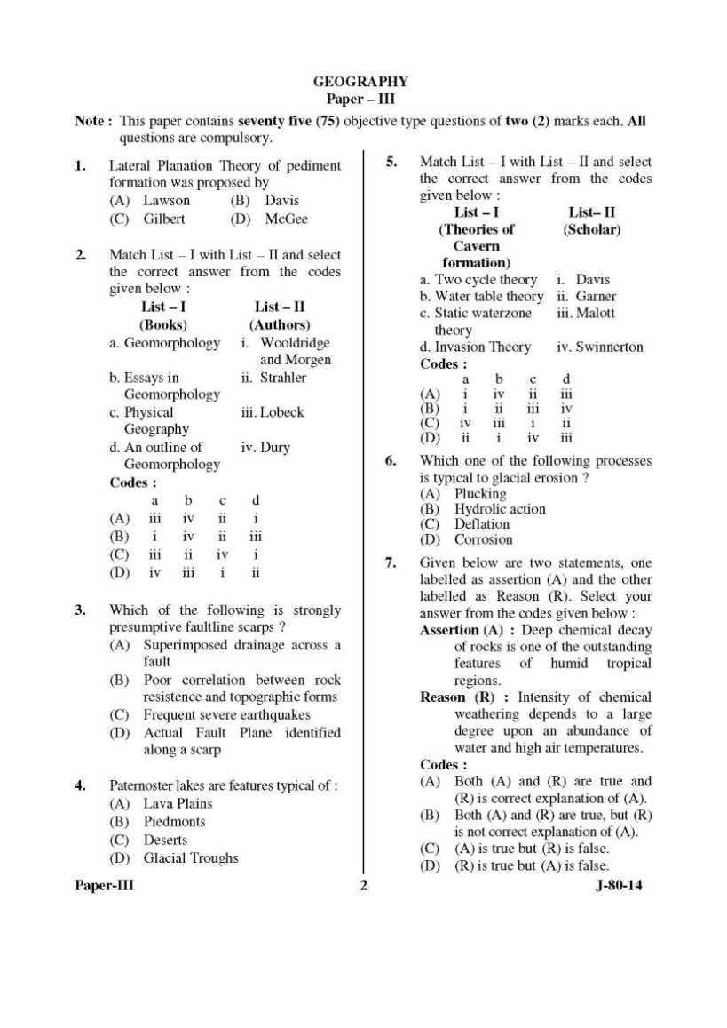    For detailed paper, here is attachment.............................
__________________ Answered By StudyChaCha Member |
 |
| |


